Shoreham, Pluto and
Otford
Distance:
4.8 Miles (2.25 Hours)
OS Map:
Explorer 147 (Start at grid reference TQ518615)
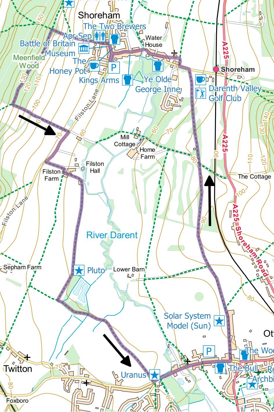
Click map to magnify and click
again to magnify further
Park in the free public car park in
Shoreham – from the High Street, drive south past the
end of Church Street on the left and into Filston Lane
(effectively a continuation of the High Street) where
the car park is on the left.
You could shorten the walk by half
a mile and avoid the only climb by walking along Filston
Lane to the entrance to Filston Farm.
The road is not a busy one, but great care should
be taken nonetheless.
Otherwise, turn right along the
main street, pass Church Street on the right and soon
reach the Aircraft Museum on your left (open 10am to 5pm
every Sunday from May until the end of September).
Immediately past the museum take a track uphill
on the left signposted to Halstead and Timberden Bottom.
Climb steadily to a terrace where there are two
seats. Turn
left along a broad track, initially along lower edge of
woodland.
On entering an open field, turn
sharp left down to gate and along track between hedges.
At lane turn right for 250 metres to track
leading to Filston Farm and take footpath on far side
running parallel to track.
Pass to the left of the large barn then turn
sharp right to a large silo on metal legs bearing
several waymarks.
Here turn sharp left downhill through two gates
past some stables into a lane.
Follow the lane, soon bearing right and becoming
quite muddy in wet weather.
Continue to a white concrete post
beside the path.
This is Pluto – part of Otford’s largest scale
model of the solar system on Earth.
Carry on until you reach a path at a T-junction
and turn left to follow a well-defined path that leads
over a small bridge and across fields to join the road
on the outskirts of Otford.
Turn left along Otford High Street,
passing Uranus on the left, and cross at a pedestrian
island before the footpath on the left ends.
On reaching the public car park and toilets on
the left, cross the road and go through the car park to
the recreation ground.
At the far side of the recreation ground is the
main part of the solar system model – the Sun, Mercury,
Venus, Earth and Mars.
Jupiter is on the edge of the recreation ground.
Leave the recreation ground at the
northeast corner and turn left along a lane.
When the lane turns left, go straight forward
through a gate along a path between hedge and fence.
Follow this path through the golf course.
Cross a lane and carry on along the path, round
the edge of the cricket field and past the golf course
clubhouse to Station Road in Shoreham.
Turn left and take the first footpath on the
right. After
a few yards go through a gate on the left into the
churchyard.
Go straight through the churchyard, noting the church
porch, reputedly carved from a single tree trunk – are
you convinced?
On emerging into Church Street go
straight forward, across the bridge and up the hill to
the High Street.
Turn left along Filston Lane back to the car
park.
|
Points of Interest
Solar System Model

The model, the largest in the world, was created to
celebrate the millennium and shows the relative
positions of the Sun and planets at midnight on 1
January 2000. Considerable effort was required to
design an accurate layout that gave public access to
every planet. Each planet is on a concrete pillar,
drawn to the same scale as the model as a whole. On
this scale, the nearest star would be in Los Angeles.

Tea Shop Crawl
This walk is well endowed with places of refreshment.
Otford has two pubs and a tearoom.
The Clubhouse at Darenth Valley Golf Course welcomes
walkers. It is open most days but is closed 25 and
26 December and 1 January.
Honey Pot Tearoom is
normally open 11 to 4 Thursday to Saturday.
There are also four pubs in Shoreham, two of them
passed on this walk.
Public Transport
This walk is easily accessible by public transport,
passing close to both Shoreham and Otford railway
stations where there are regular services from Sevenoaks
and Bromley.
In addition to the walking routes on our web site we
have published three popular walking guides:

Guide to Tunbridge
Wells Circular Walk and other walks in the area

Guide to the
Kent Coast Path: Part 1, Camber to Ramsgate

Guide to Three
River Valley Walks in West Kent: Darent Valley Path,
Eden Valley Walk and Medway Valley Walk
Please report any problems with this walk to
info@kentramblers.org.uk.
Ramblers' volunteers in Kent work tirelessly to
ensure that our paths are as well protected and
maintained as possible. Of course we also organise
led walks but most of our members are independent
walkers who simply want to support our footpath work.
Please
join us and become a supporter too. You need
us and we really need you.
Map contains Ordnance Survey data © Crown copyright
and database rights 2020. Some paths on map are based
on data provided by Kent County Council but do not
constitute legal evidence of the line of a right of way |