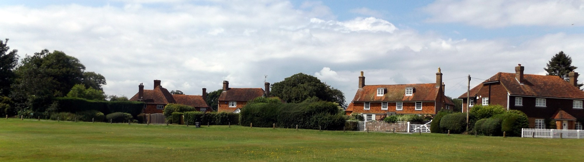
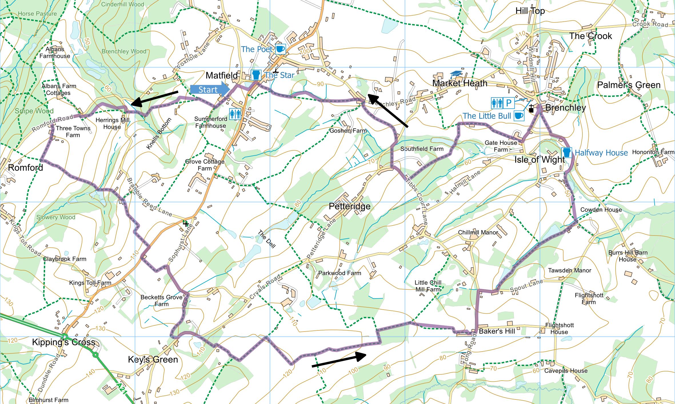
Matfield and Brenchley
Distance:
7.7 Miles (3.5 Hours)
OS Map:
Explorer 136 (Start at TQ657418)
Click map to enlarge and click
again to enlarge further
There is a parking area at side of green furthest
from road.
From parking area head for nearest corner of green
and take track to right of sports pavilion. At end
of fence on the right, take path through gate between
fences. After a couple of hundred metres go over
stile on left and bear right across field to copse (aim
for electricity pole). Through copse, cross
another field diagonally right downhill to stile (which
needs mending and some new waymarks) and go through
stretch of woodland. Cross short meadow uphill to
Bramble Reed Lane. Turn right and after a few
metres take path on left climbing through woodland (fine
wood anemones and bluebells in spring) then bearing left
along right hand edge of an orchard (note that this is
different from the route shown on Ordnance Survey
Explorer map). At lane (Romford Road), turn left
uphill following High Weald Landscape Trail for 200
metres to parking place on right where HWLT goes into
wood.
Turn left along track, go between buildings at Three
Towns Farm then straight across orchard to stile in
corner of hedge. Over stile, bear left between
fences and follow path along left hand side of field
divided into paddocks, soon descending to go through
plat (cob nut orchard) to footbridge over stream.
Across second footbridge go into field (obstructed by
electric fence at time of writing), climb straight up to
stile and follow rough track uphill through gate to
asphalt track near buildings. Cross track at
corner, go up bank into field, turn right along bottom,
and go over stile. Initially follow hedge but be
bear gently left uphill to stile at left hand end of
line of oaks.
Go along left hand side of field, turn right at
corner and halfway along next side go through gate on
left. Follow sometimes overgrown track to
Maidstone Road.
Turn right and just after building take path on left,
initially alongside hedge on left then straight across
field to hedge. Turn left and soon (after house)
take path through hedge on right to Sophurst Lane.
Turn right along lane and at bottom turn right up
concrete farm track past stables at Becketts Grove Farm.
Just after last shed on left, go round large metal gate
and follow path between fences along edge of woodland.
Follow path left through wood to Cryals Road and turn
left downhill. As road bears left at bottom, take
path into woods on right.
Cross drive, climb steps and bear right uphill along
right hand side of field. As path levels out, turn
sharp left along grassy track with view of Brenchley
church straight ahead in distance.
At crossing of paths (by first hedge on left) turn
right. At T junction turn left. Continue
into orchard, at tall hedge bear right along track
beside hedge and follow to end. Turn left (for 100
metres) and go over stile on right. Follow path
between fences to gate. Go through and then
straight ahead along right hand edge of orchard then
bear right for a few metres and left along hedge.
On approaching corner go right through hedge and left to
Tong Lane.
Turn left. Go straight ahead at first junction
(with Marle Place Road). Head down hill and turn
right at bottom along Spout Lane. Take first path
on left (WT 307) opposite third house. Walk along
valley keeping to right hand side, passing orchards and
lake. On reaching wooden footbridge, cross and
follow path uphill between fences, eventually joining
farm track down to lane.
Turn right then left at junction past Halfway House
pub. As road levels out a little, just after 30
mph sign, take path up brick steps on right and climb
across field to Horsmonden Road. Turn right uphill
to Brenchley church and village facilities.
Go through churchyard, keeping left and taking path
heading down the top of a bank above Horsmonden Road.
On descending to road at junction, keep right and take
path first on right along track that is initially
asphalt but soon just stony (between buildings of former
Gate House Farm). In due course follow stony track
round to left, past pond, then uphill and bearing right
between hedges to Tibbs Court Lane.
Turn right up lane and at first left hand bend take
path on right downhill to Petteridge Lane. Turn
right but soon take bridleway on left between fences and
emerging onto Brenchley Road.
Turn left but very shortly take first ungated track
on left and follow between fences. On emerging
into open field planted with blackcurrant bushes go
forward to where hedge on right protrudes into field –
path strictly goes across field but if hard to find then
follow right hand edge instead. Either way
continue along right hand edge until Matfield comes into
sight. Take path between houses to reach green at
Matfield where there are pubs or seats on green for
eating sandwiches.
|
Points of Interest
Matfield House
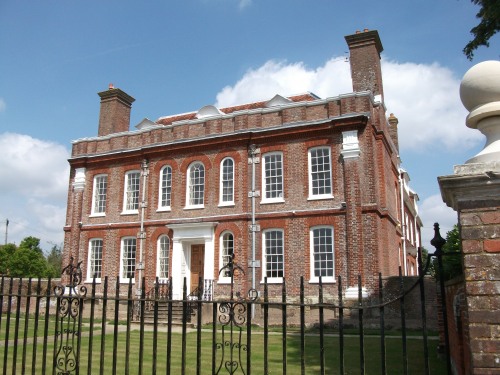
There are many attractive
buildings around the village green at Matfield but the
most striking, on the north side, is the red-brick
Matfield House. This was built in 1728 for Thomas
Marchant and is generally reckoned to have been designed
by the same architect as Finchcocks (see Walk 43).
Set back and to the right are the equally elegant
stables with a clock turret described in the Pevsner
guide as “much too large”.
Public Transport
The number 6 bus runs a roughly
hourly service between Tunbridge Wells and Maidstone,
visiting Matfield. Number 297 bus runs every
couple of hours from Tunbridge Wells to Brenchley on its
way to Tenterden. Neither bus runs on Sundays.
Please report any problems with this walk to
info@kentramblers.org.uk.
Ramblers' volunteers in Kent work tirelessly to
ensure that our paths are as well protected and
maintained as possible. Of course we also organise
led walks but most of our members are independent
walkers who simply want to support our footpath work.
Please
join us and become a supporter too. You need
us and we really need you.
Map contains Ordnance Survey data © Crown copyright
and database rights 2024. Some paths on map are based
on data provided by Kent County Council but do not
constitute legal evidence of the line of a right of way.
Guide to Tunbridge
Wells Circular Walk and other walks in the area

Guide to Three
River Valley Walks in West Kent: Darent Valley Path,
Eden Valley Walk and Medway Valley Walk
|