Groombridge, Eridge
Rocks and Harrison’s Rocks
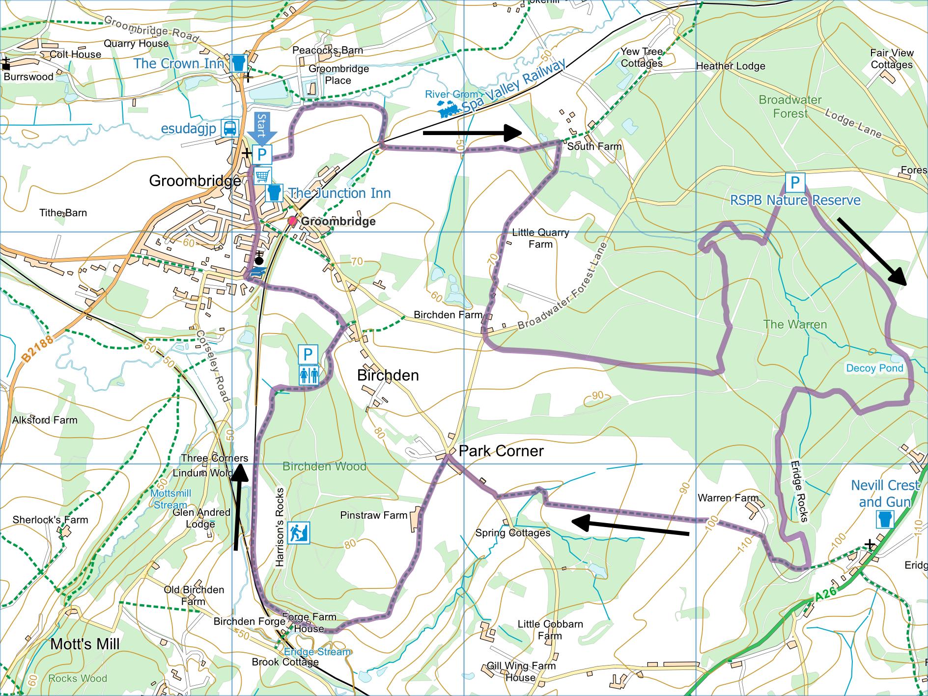
Distance:
8.2 Miles (4 hours) excluding extension to Eridge Green
for pub visit
OS Map:
Explorer 135 (Start at grid reference TQ533364)
Click map to enlarge and click
again to enlarge further
Park in free car park adjacent to Groombridge Village
Hall or nearby. Alternatively you could park at
the RSPB Broadwater Warren free car park and start the
walk from there.
Take path out of car park at corner opposite entrance
alongside left hand edge of playing field, through gate
and along track between fences. On reaching gravel
track, follow fence round to right and take path along
avenue of lime trees. Enter field and follow path
between fences to far right hand corner.
Bear right along path and under railway. Over
stile, turn left along left hand edge of field to bridge
and gate. Follow intermittent line of oak trees to
next stile then cross the middle of two meadows to
protruding hedge. Keeping hedge on right carry on
into woodland past pond.
Turn right before buildings, cross yard and bear
right onto path along left hand edge of meadow and into
wood. Beyond wood follow left hand edge of fields,
passing isolated house on left. At corner bear
left through gate into wood and follow path to Birchden
Farm. Go between oast house and barn and head
straight forward to lane at junction.
Cross lane at junction and immediately take path
through gate on left. Follow path through woodland
until it joins broader path. Turn right for 30
metres then bear left through gate at fork. After
another 560 metres at T-junction turn left. At
crossing of broad tracks look for narrower path into
trees just left of straight ahead, through tall pines.
On descending steps to junction of tracks take second
left (fairly level track) and after 50 metres take
narrower path on right at post, crossing series of
duckboards. On meeting broad track turn right, left at
T-junction then first left soon climbing to car park.
Take broad track to right of information board, turn
right after a gate and follow broad track to decoy pond.
Continue uphill (following green waymarks which point in
opposite direction), ignore two right turns but turn
right at junction of four paths. Keep right at
next junction. On reaching a large oak,
information board, pond and waymark post on right, turn
left past Sussex Wildlife Trust sign and follow track
beneath Eridge Rocks all the way to small car park. Here
you can turn left along asphalt track for detour to pub
(Nevill Crest and Gun) at Eridge Green. Otherwise…
Turn right along asphalt track and after a couple of
metres take path on right through bracken until it
rejoins asphalt track. Turn right and, immediately
after woodland on left ends, take path on left passing
well to left of farmhouse and soon heading downhill
across the middle of a very large field.
At far edge of field turn right along field edge to
corner, descend to cross footbridge and follow right
hand edge of field to lane. Turn right along lane
and at top of hill take track on left. Pass
Pinstraw Farm and carry on between buildings at Forge
Farm then on through trees to emerge into open meadow
with Harrison’s Rocks on right and Spa Valley Railway on
left. Follow path alongside railway then turning
right towards car park for climbers in Birchden Wood
where there may be a coffee van from Wednesday to
Sunday. Follow track up right hand side and then
along top of car park, climbing to meet asphalt drive.
Turn right and at end of first field on left take
path on left between fence and hedge. Follow path
to bridge across railway and up to road by school.
Turn right and follow Corseley Road back to car park.
In addition to the walking routes on our web site we
have published three popular walking guides:

Guide to Tunbridge
Wells Circular Walk and other walks in the area

Guide to the
Kent Coast Path: Part 1, Camber to Ramsgate

Guide to Three
River Valley Walks in West Kent: Darent Valley Path,
Eden Valley Walk and Medway Valley Walk
|
Points of Interest
Spa Valley Railway
The line from Tunbridge Wells to Eridge was closed by
British Rail in 1985. The line was reopened by
volunteers, running from Tunbridge Wells West to
Groombridge in 1997. A connection to the main
railway network at Eridge was restored in 2011 but there
seems little prospect of restoring the link from
Tunbridge Wells West to the main line at Tunbridge Wells
(formerly Tunbridge Wells Central).
The line runs a mixture of steam-hauled services and
“heritage diesel” locomotives.
Broadwater Warren
The RSPB acquired the site in 2007 and are removing
large patches of conifer either to restore to heathland
or to replace with native broadleaves.
Eridge Rocks
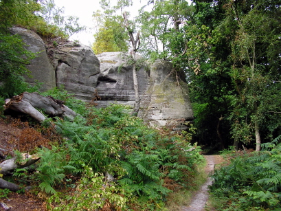
This is a Site of Special Scientific Interest managed
by Sussex Wildlife Trust as a nature reserve.
Forge Farm and Harrison’s Rocks
Forge Farm is on the site of old Birchden Forge.
Here the stream was used to power a bellows to forge
iron, last used by William Harrison to make firearms
until 1750. Finding this unprofitable, he opened
the land to people wanting to visit see the scenery,
especially the 40ft sandstone outcrop now owned by the
British Mountaineering Council. It is rare not to
see rock climbers training here.
Groombridge Place
A 17th century manor house surrounded by a medieval
moat, used as a location in the 2005 film Pride and
Prejudice. It is not currently open to the public.
Public Transport
Groombridge is accessible by the Spa Valley Railway
from Tonbridge Wells or bus service 291 from Tunbridge
Wells, East Grinstead and Crawley.
Please report any problems with this walk to
info@kentramblers.org.uk.
Ramblers' volunteers in Kent work tirelessly to
ensure that our paths are as well protected and
maintained as possible. Of course we also organise
led walks but most of our members are independent
walkers who simply want to support our footpath work.
Please
join us and become a supporter too. You need
us and we really need you.
Map contains Ordnance Survey data © Crown copyright
and database rights 2023. Some paths on map are based
on data provided by Kent County Council but do not
constitute legal evidence of the line of a right of way. |