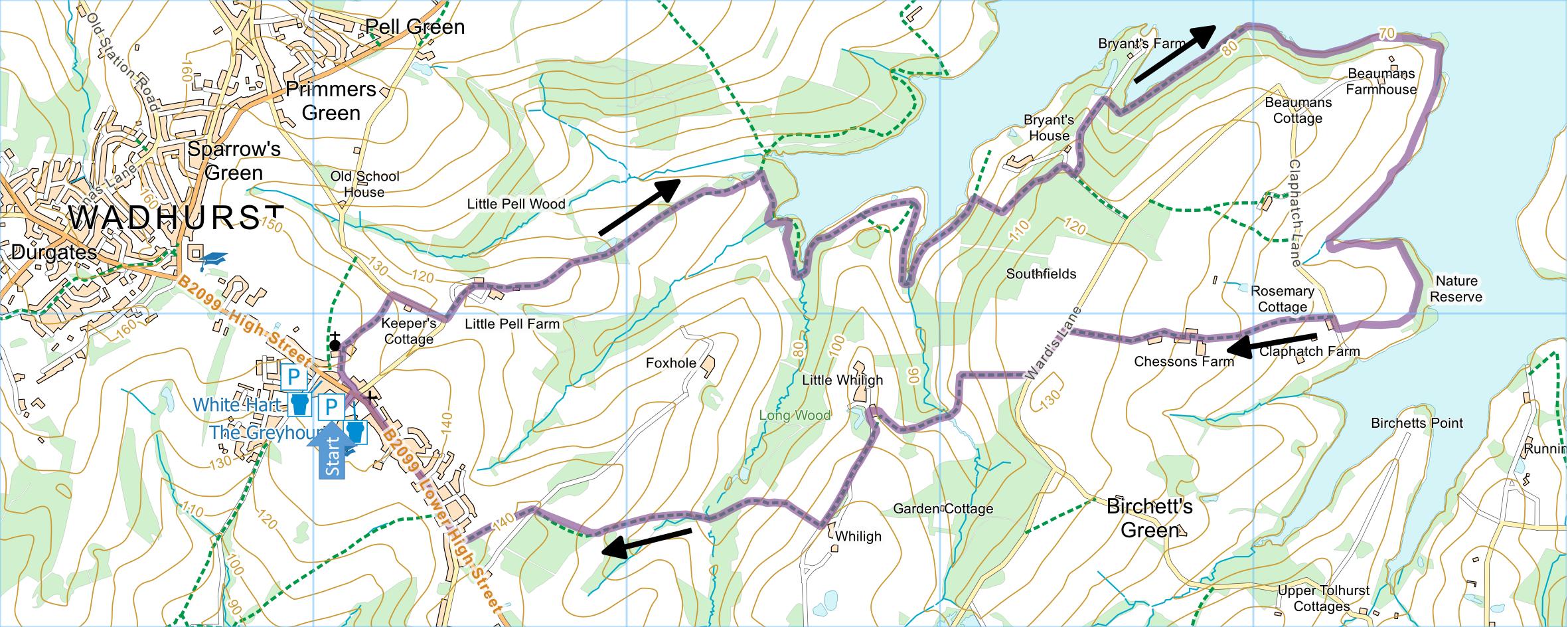
Wadhurst and Bewl
Water
Distance: 6.8 Miles (3h 20m)
OS Map: Explorer 136
(Start at grid reference TQ641307)
Click map to enlarge and click
again to enlarge further
Park in one of the free car parks in Wadhurst.
There are two car parks – a smaller one off White Hart
Lane (which goes down the side of the White Hart Inn)
and the recommended one whose entrance is down the side
of the Greyhound Inn.
From the Greyhound Inn cross the High Street and bear
left behind a white building (formerly the NatWest bank
but currently for sale) along Church Lane. At the
end enter the churchyard, keep right of the church and
bear right out of the churchyard along a path past a No
Cycling sign to Blacksmith’s Lane.
Turn right and walk downhill to the corner.
Turn left along a gravel track past Little Pell Farm.
Take the most straightforward route through the farm and
along the left hand edge of a field. The track
becomes enclosed between hedges and passes a pond on the
left. When track turns sharp left, go straight
ahead into narrow wood. Continue, crossing several
stiles, until you emerge over stile into field.
Skirt the edge of a wood on your left. Bear
downhill and over a stile to join a broader path at a
T-junction. Turn right and eventually reach the
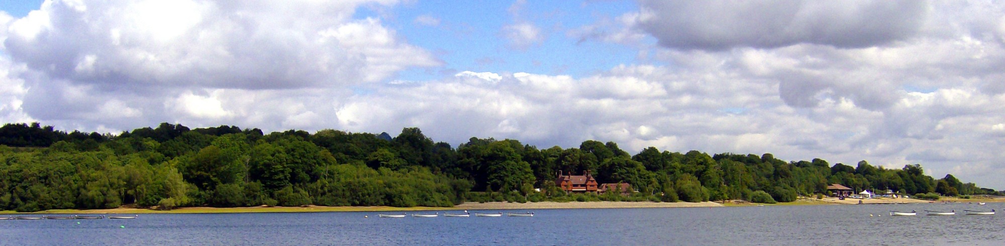
shore of Bewl Water.
Follow the Round Bewl Water Walk along the shore and
through a gate on the right up quite a steep hill.
At the top, follow the path to the left and reach a
metalled lane. Turn right uphill but very soon
take a concrete track downhill on the left towards
Bryant’s Farm. (Don’t follow the Bewl Water Route
which continues uphill.) Halfway down the track,
just before a gateway, take a path on the right
signposted to Hook Hill. Go down some wooden steps
then follow the path as it bears left and follows the
lake edge.
Soon after a seat and shelter, reach the bottom of
Hook Hill. Continue forward on a path parallel to
the shore. This path is not a recorded right of
way and is not marked on the OS Explorer map (although
it is on the Landranger!) but it is a clear and
well-maintained path passing through woods and then some
delightful wildflower meadows alongside a creek popular
with waterfowl. Be careful at point at the end of
the creek where the wrong path going forward to the lane
is more obvious than the correct path on the left.
Follow this path until you can go no further because the
path ahead leads only to a hide and there is a nature
reserve on your left. Turn right up a metalled
path between hedges to a lane.
Turn right and, immediately after Rosemary Cottage on
the left, turn left up drive, through large gate and
follow a footpath along the right hand edge of three
fields to Chesson’s Farm. Go straight through the
farm and along a metalled track to a lane.
Turn left and just before the lane becomes enclosed
in trees take a path through a gate on the right.
Go down the right hand edge of a field and between two
large trees into the next field. Turn sharp left
along field edge to a track between banks that gradually
bears right, downhill to a gate and a bridge over a
stream. Over the bridge bear right along the edge
of a wood; but when the fence bears right go straight on
up the hill and then bear right again to a gate to the
right of the nearest building. Once through the
gate, turn left along an asphalt lane until you come to
a large house on the left.
Go through a kissing gate on the right and down the
right hand edge of a field. About two thirds of
the way down, bear left towards the valley bottom and a
stile into a wooded glade. When the path through
the glade meets a broader track, bear right over a
bridge. Bear right again into a field and then
turn left, uphill along the left hand edge of the field.
At the corner of the field, bear right uphill still
following the left edge of the field to a lane.
Go straight across the lane into another field.
Bear left to the opposite corner of the field and onto
the main road. Turn right and follow the road
(there is a pavement all the way) into Wadhurst and back
to the car park.
|
Points of Interest
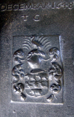
Wadhurst and the Wealden Iron Industry
Wadhurst was one of the chief
centres of the Wealden iron industry from the 16th
to the 19th centuries.
The church contains more iron tomb slabs than any
other in the country, such as the one below:
Public Transport
Service 1066 from Tunbridge Wells railway station to
Wadhurst also passes Wadhurst railway station which is
somewhat out of town and offers a roughly hourly service
from Monday to Saturday and a roughly two-hourly service
on Sunday. Service 256 also runs from Tunbridge
Wells railway station to Wadhurst (but mostly not
Wadhurst railway station) half a dozen times a day
Monday to Friday only.
Please report any problems with this walk to
info@kentramblers.org.uk.
Ramblers' volunteers in Kent work tirelessly to
ensure that our paths are as well protected and
maintained as possible. Of course we also organise
led walks but most of our members are independent
walkers who simply want to support our footpath work.
Please
join us and become a supporter too. You need
us and we really need you.
Map contains Ordnance Survey data © Crown copyright
and database rights 2023. Some paths on map are based
on data provided by Kent County Council but do not
constitute legal evidence of the line of a right of way.
In addition to the walking routes on our web site we
have published four popular walking guides:
Guide to the Wealdway

Guide to Tunbridge
Wells Circular Walk and other walks in the area

Guide to the
Kent Coast Path: Part 1, Camber to Ramsgate

Guide to Three
River Valley Walks in West Kent: Darent Valley Path,
Eden Valley Walk and Medway Valley Walk
|