Harbledown and Dunkirk
Distance: 10.7 Miles (5 Hours)
OS Map: Explorer 149 & 150 (Start at
TR125581)
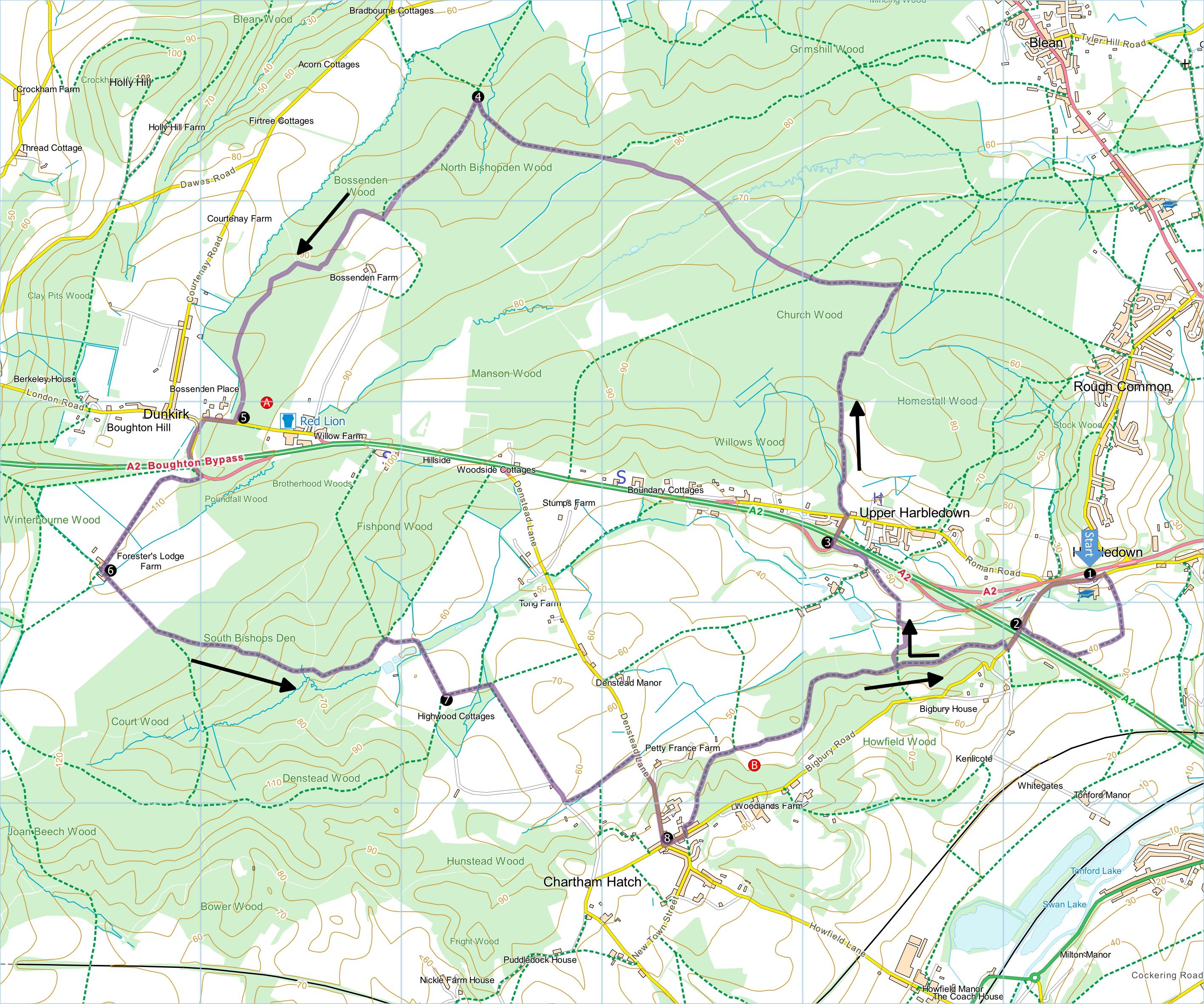
Click map to magnify and click
again to magnify further
Start at Lower Harbledown, 2 miles west of Canterbury
(Kent College Canterbury)
1 Set off with school on your right
and immediately past school take path on right down to
bridge and up through orchard to concrete farm track.
Turn right and at end of track continue across a field
to gap in hedge; on other side join North Downs Way.
Turn right downhill and continue to road.
2 Turn left along road, over the A2
and take path through kissing gate on right. Soon
follow North Downs Way through gate on left. At
first junction just before information board and gate
take waymarked path on right down through wood and
across field of hops (the path should go straight across
but currently there is a diversion to the right before
turning left across the field) to a small bridge; cross
and go up through orchard to waymark and bear left.
Follow hedgerow round to access road, then up over the
A2 to Upper Harbledown.
3 Cross bridge and follow road to
the T-junction, bearing right of small village hall at
junction and take adjacent public footpath. Follow path
around back of village hall then climb steadily through
woodland, after 900 metres or so bearing right and
joining a broader track near a bend. Turn left for
400 metres to a crossways and turn left along a broad
stony track. Follow for 1.5 miles (2.4 km) until
path joins bridleway at T-junction (post with both
yellow and blue roundels).
4 Turn left and continue for 750
metres to next T-junction where the bridleway goes left.
Turn right past wooden barrier along perimeter of
Bossenden Farm then left at corner. At junction of
four paths, turn right along most level path and at fork
bear left. Follow track to road.
5 For Red Lion pub, go left.
To continue the walk turn right along road, take first
left back over the A2 and then turn right along access
road to Foresters Lodge Farm.
6 Amid farm buildings, take path on
left between buildings along left hand edge of field.
Enter South Bishops Den Wood and at fork bear left.
Heading downhill cross a broader track and just as path
bears left and starts to climb, go forward onto narrower
path; if you find you are climbing steadily, you have
missed the turn. When you reach the edge of the wood
at a T-junction with mesh fence ahead, turn left along
the fence until you reach a stile. Cross the field
to far L-hand corner, go over stile and continue
straight through a small copse, out into the orchards.
Keeping to the hedgerow climb to farm track and turn
left.
7 Go downhill, through narrow strip
of woodland at lowest point, immediately turn right and
continue uphill along the hedgerow to narrow lane. Go
forward down lane and at fingerpost (finger missing at
time of writing) turn left along byway to Denstead Lane.
Turn right up steep hill into Chartham Hatch.
8 Turn
left past Village Hall and turn left into Bigbury Road.
Soon turn left along North Downs Way past playing
fields to “No Mans Orchard”. Continue to follow North
Downs Way and soon rejoin outward route in opposite
direction. On reaching lane, turn left downhill,
across A2 and uphill to your starting point.
|
Points of Interest
A At Dunkirk the last armed uprising in England
took place in 1838. After a pitched battle with
the army, the body of the rebel leader, William
Courtenay, was displayed at The Red Lion.
B No Man’s Orchard: the apple orchard has been
left to grow naturally for the wild life to flourish
with many old varieties of apple; woodcarvings are laid
out amongst the trees.
Public transport: Bus No. 3 (Canterbury to Faversham)
In addition to the walking routes on our web site we
have published three popular walking guides:

Guide to Tunbridge
Wells Circular Walk and other walks in the area

Guide to the
Kent Coast Path: Part 1, Camber to Ramsgate

Guide to Three
River Valley Walks in West Kent: Darent Valley Path,
Eden Valley Walk and Medway Valley Walk
Ramblers' volunteers in Kent work tirelessly to
ensure that our paths are as well protected and
maintained as possible. Of course we also organise
led walks but most of our members are independent
walkers who simply want to support our footpath work.
Please
join us and become a supporter too. You need
us and we really need you.
Map contains Ordnance Survey data © Crown copyright
and database rights 2020. Some paths on map are based
on data provided by Kent County Council but do not
constitute legal evidence of the line of a right of way. |