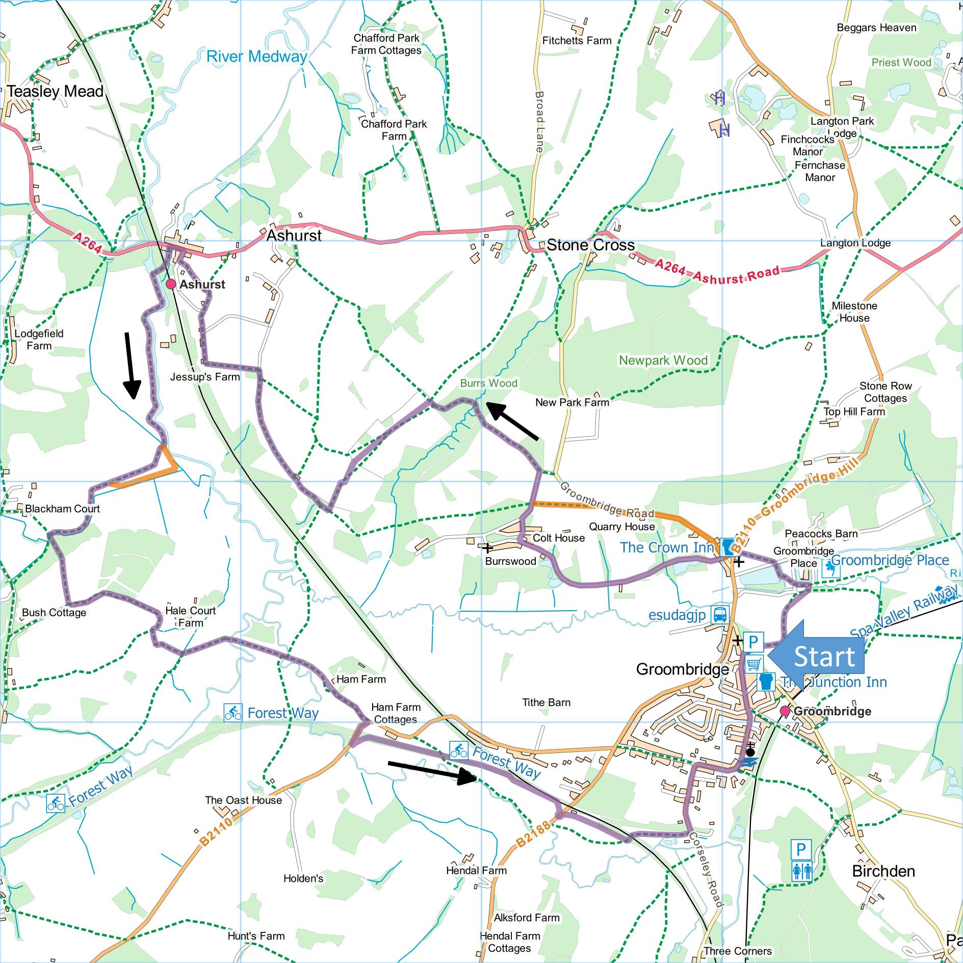
Groombridge and Ashurst
Distance: 7 Miles (3h 30m)
OS Map: Explorer 135 (Start at grid
reference TQ531373)
Click map to magnify and click
again to magnify further
Park in the free public car park off Station Road in
Groombridge or, if the car park is full, in street
further up Station Road.
Take path that leaves car park from corner furthest
from entrance. Follow left hand edge of playing
field and go through kissing gate. Turn left along
broad track then bear right alongside fence to bridge
over River Grom. Across bridge, turn left with
moat on your right. Beyond house, followcurving
iron fence (which should be immediately on your right)
and pass between two ponds up steps to lake. Turn
right along lake edge, cross drive, go through gate and
bear left along clear path that goes to right of church
and emerge on road opposite The Crown Inn.
Keep straight ahead to the entrance to the grounds of
Burrswood. Go along the Burrswood drive, passing
lakes and then buildings until you reach main house and
gateway bounded by stone pillars. Turn right
uphill before gateway (signposted “Exit”) and turn right
at T-junction at the top. Follow “Exit” driveway
until it turns sharply right in front of metal gate
beyond which is a sign inviting you to explore Burrs
Wood.
[Note: Walkers have long been welcome to walk
the drives through Burrswood’s grounds. However,
they are not recorded as public rights of way and the
estate changed hands in 2020. So far no action has
been taken to exclude walkers but should that happen it
may be necessary to take an alternative route from
Groombridge Green to the entrance to Burrs Wood.
Instead of going through Burrswood entrance, go up lane
(known as Bird in Hand Street) for 600 metres passing
two houses on left to stile on left. Take roughly
level path across field to exit drive from Burrswood and
turn right uphill to entrance to Burrs Wood at corner.
This route is shown in orange on the map.]
Take track to left of this sign and follow it
downhill, eventually entering wood. Bear right and
descend to bridge across stream. Go uphill to
first junction where there is a fingerpost (but in such
a state of decay it may soon be gone) and bear left.
Thereafter bear right at junctions, climbing gradually
through wood.
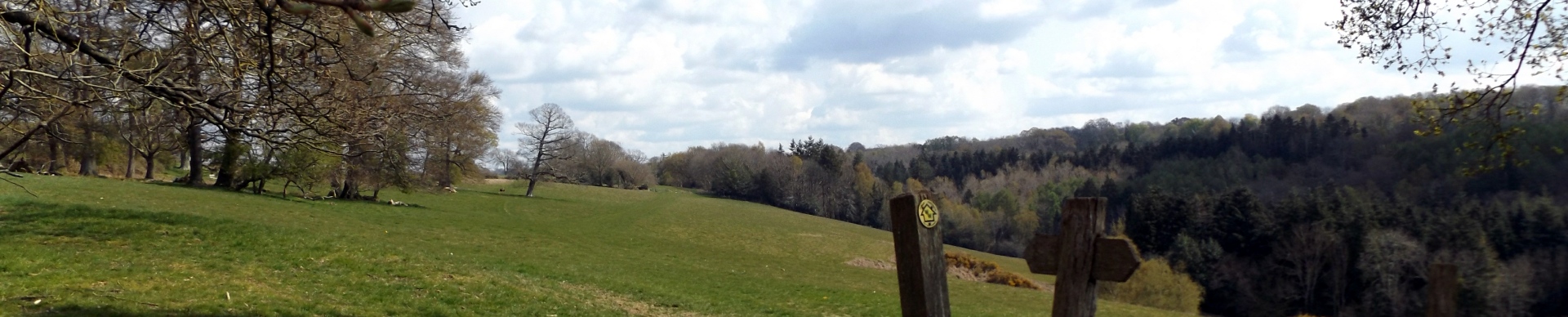
On emerging into field, climb briefly to meet path
(Wealdway) coming through gate on right and turn left
along it. Cross large field, neither climbing nor
descending much but getting fine views of surrounding
countryside. At far side of field make for gate
some way down from top and go through. Follow
hedge/fence on right until gate leading through it;
through gate turn left and follow same hedge now on your
left and into meadow at bottom. Turn right and
follow Sussex Border Path past some trees and some
derelict buildings then along the right hand side of
clearing to gate and track. At first junction in
track, turn left downhill to track by farm and turn
right along it. When track bends left downhill, go
through small picket gate on right and across top of
garden passing close to house. Follow short
section of path into open field. Head downhill
diagonally across field making for lowest point at far
corner and stile into lane. Turn right along lane
to main road.
Turn left and immediately after Millstream Close
(well before railway bridge) take path on left alongside
fence. Follow path under railway and across
footbridge over Medway. Turn left along river bank
for 800 metres. At first hedge across path go
through gap and continue along left hand edge of field
to corner. Turn right along bank of ditch (on your
left) and continue to hedge at end of field.
[Strictly the path goes across the field rather than
along the edge but I have never found the strict route
restored after ploughing so the field edge is a better
bet.]
Go through hedge, turn left and follow field edge to
footbridge on left at corner. Over bridge, go
straight ahead through woodland and over stile.
Follow left hand edges of two fields uphill to concrete
track. Turn left and follow track as it bends
right downhill towards Hale Court Farm.
Immediately before farm entrance, turn right along field
edge for 75 metres and just before lowest point of field
take narrow path on left (if you start climbing you have
missed it and gone too far). Follow path between
hedge and fence then emerge across footbridge into large
field. Bear half left across field to bridge over
Medway; continue across field and another bridge then
ahead uphill past Ham Farm to road.
Turn right until you reach Forest Way and turn left
along it. Follow Forest Way until it reaches next
road (B2188) and cross it. Continue alongside
railway embankment, then under railway and down to
Corseley Road. Turn left uphill and right at
T-junction at top. Follow road round to left past
school and church then downhill to join Station Road
just opposite car park.
|
Points of Interest
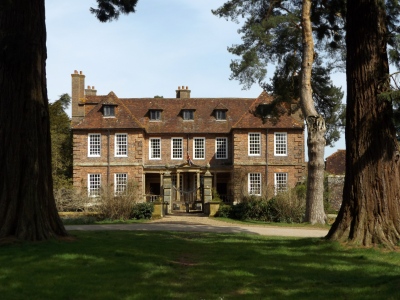
Groombridge Place
Pill Box Heaven
This part of the Medway valley is a mecca for pill
box enthusiasts. There are apparently over 40
between Ashurst and Penshurst. They are part of
the “GHQ Stop Line” of anti-tank defences that ran east
from Somerset to Kent and then north to Yorkshire.
It was built in the early 1940s to hinder Hitler should
he invade Britain from the south or east. The pill
boxes would have been manned by the Home Guard armed
with machine guns and rifles fired through the slits.
Public Transport
Take the train to Ashurst station and start the walk
there. Another option is to take the bus from
Tunbridge Wells to Groombridge.
In addition to the walking routes on our web site we
have published three popular walking guides:

Guide to Tunbridge
Wells Circular Walk and other walks in the area

Guide to the
Kent Coast Path: Part 1, Camber to Ramsgate

Guide to Three
River Valley Walks in West Kent: Darent Valley Path,
Eden Valley Walk and Medway Valley Walk
Please report any problems with this walk to
info@kentramblers.org.uk.
Ramblers' volunteers in Kent work tirelessly to
ensure that our paths are as well protected and
maintained as possible. Of course we also organise
led walks but most of our members are independent
walkers who simply want to support our footpath work.
Please
join us and become a supporter too. You need
us and we really need you.
Map contains Ordnance Survey data © Crown copyright
and database rights 2020. Some paths on map are based
on data provided by Kent County Council but do not
constitute legal evidence of the line of a right of way |