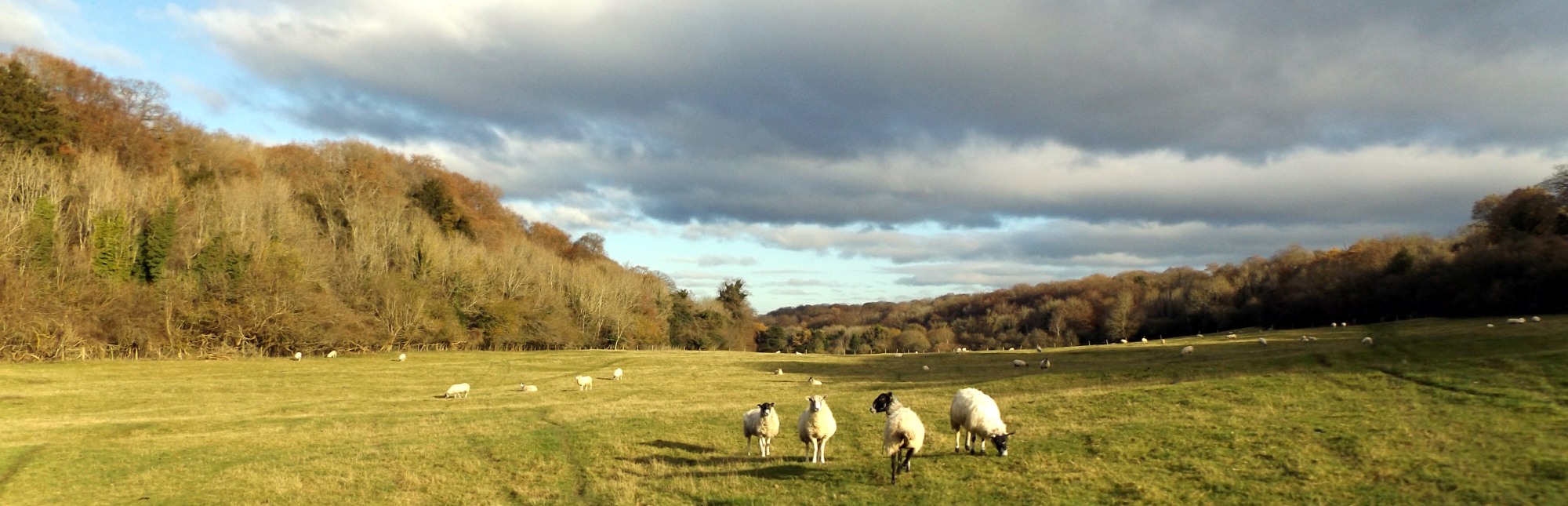
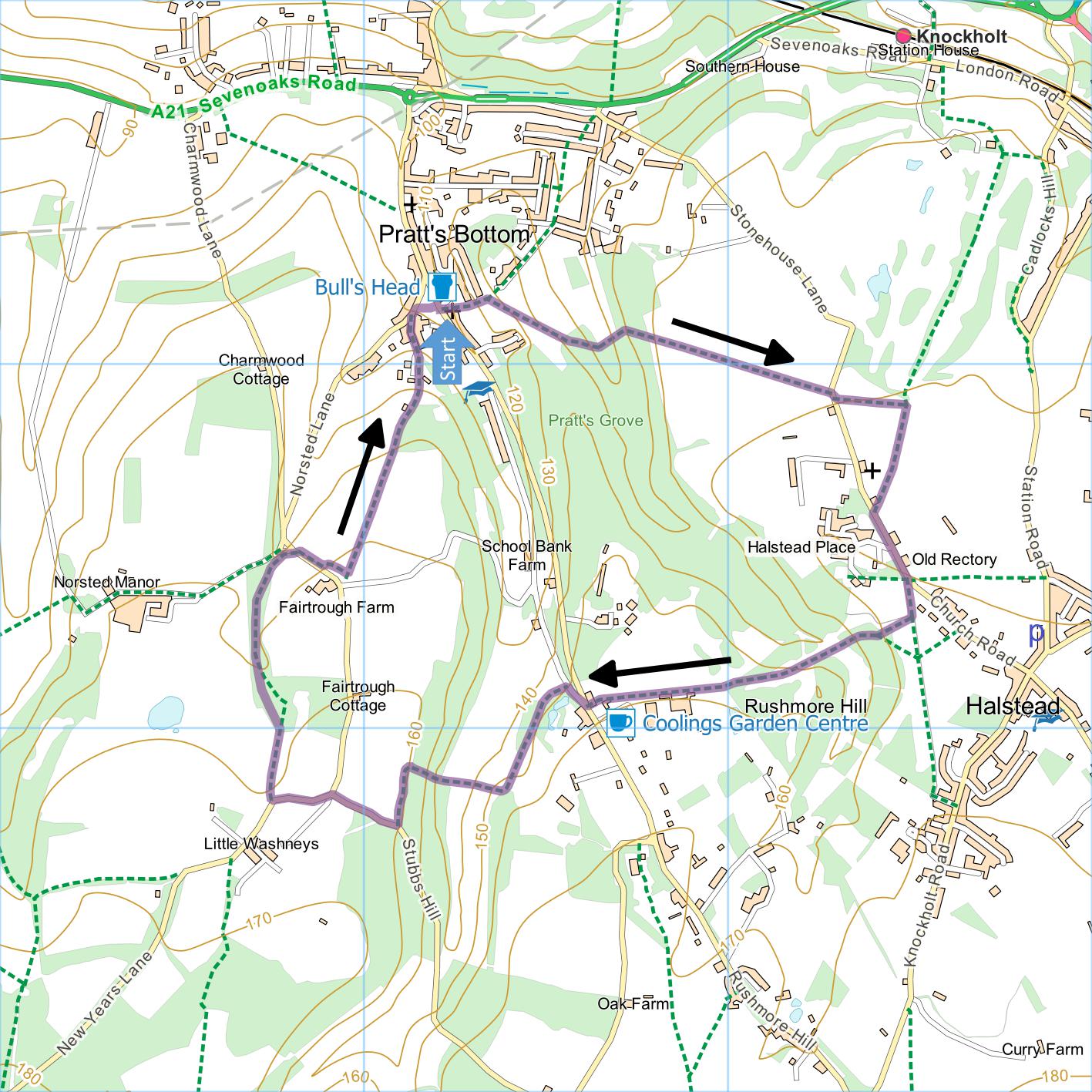
Pratts Bottom and Halstead
Distance: 3.7 Miles (1.5 hours)
OS Map: Explorer 147 (Start at grid
reference TQ474618 )
Click map to enlarge and click
again to enlarge further
Parking: Turn up Rushmore Hill from Pratt’s
Bottom roundabout on A21 to village green. Park in
Ringwood Avenue (first left after Bull’s Head), near
village green or on non-school days opposite school
(first right after village green).
Take path between Pratts Bottom Free Church and the
Bull’s Head car park. At top of steps turn right
over stile between fences then almost immediately go
over stile on left. Cross field diagonally to far
corner and go over stile into wood.
Follow path downhill through wood to fence corner at
bottom. Bear left, uphill, with field on left at
first. Continue out of wood and across field to
Stonehouse Lane.
Bear right across lane and take path
alongside golf course. At waymarked post go
through gate on right and follow track, passing well to
left of church, to rejoin Stonehouse Lane. Cross
to footway and turn left. (You could miss this bit
out and just walk (right) up Stonehouse Lane instead but
there is no footway at first.) Pass entrance to
Halstead Place, former special school now converted into
housing, noting house bearing blue plaque commemorating
the work of Anna Atkins who lived and worked on the
site.
Pass Old Rectory on left and go through gate on
right. Bear left with new hedge on right to a
stile and go over. Bear slightly right across
disused golf course, soon down waymarked path with
brambles on both sides to bottom. Bear right
uphill across grassy ride between copses, gradually
moving from left to right side of ride then enter copse
on waymarked path and emerge at top left corner.
Go over stile onto narrow (and sometimes muddy) track
with Coolings Garden Centre on left. Continue to
Rushmore Hill.
Cross road and bear right, take left fork (Hookwood
Road) and after a few metres take footpath on left
signposted to Cudham. Follow broad track until
gate ahead marked “Private No Entry” then go over stile
on right. Go down to bottom of hill and over stile
into wood. Go uphill through wood. On
emerging from wood go left along top of wood to join
Perry Lane. Turn right uphill.
At junction turn left along Washneys Road. At
first left hand bend, go through stile on right along
track between two fences. In the hedgerow on the
right, amongst the wild roses and hawthorns, are several
spindle trees bearing, in late autumn, characteristic
orange seeds within pinkish-red fruits. When path
enters wood bear slightly left downhill. Continue
to Port Hill.Cross lane and go through gate. Go
sharp right uphill, parallel with road. Note
Fairtrough Farm on right, formerly an Equus Kinski stud
farm. Keep going uphill to gate into broad track
from road junction. Go through gate and turn left
along track. Follow track back to village green at
Pratts Bottom. Bear right across green and up road
to car.
|
Points of Interest
Pratts Bottom
The village is best known for a 1985 advertising
campaign that promoted Lois Jeans as “tougher than
living in Pratts Bottom”. The name is said to
derive from the Latin word “pratum” meaning “meadow”.
Halstead Place
Once the home of the Atkins family and later
demolished. Until the early 2000s the remaining
buildings and additional modern blocks were used as a
residential and day school. Now converted into
homes.
Anna Atkins (1799-1871)
There is a blue plaque on the lodge commemorating
Anna Atkins who lived and worked at Halstead Place.
She was a botanist who between 1841 and 1853 published
British Algae: Cyanotype Impressions, the first book to
be illustrated with photographs – example below.

Public Transport
The walk is ideal for travelling by train to Shoreham
Station on the route from Victoria to Maidstone or St
Pancras and City Thameslink to Sevenoaks.
Fox and Hounds
This pub at Romney Street which you may find marked
on your Ordnance Survey map is no longer open.
In addition to the walking routes on our web site we
have published three popular walking guides:

Guide to Tunbridge
Wells Circular Walk and other walks in the area

Guide to the
Kent Coast Path: Part 1, Camber to Ramsgate

Guide to Three
River Valley Walks in West Kent: Darent Valley Path,
Eden Valley Walk and Medway Valley Walk
Please report any problems with this walk to
info@kentramblers.org.uk.
Ramblers' volunteers in Kent work tirelessly to
ensure that our paths are as well protected and
maintained as possible. Of course we also organise
led walks but most of our members are independent
walkers who simply want to support our footpath work.
Please
join us and become a supporter too. You need
us and we really need you.
Map contains Ordnance Survey data © Crown copyright
and database rights 2020. Some paths on map are based
on data provided by Kent County Council but do not
constitute legal evidence of the line of a right of way |