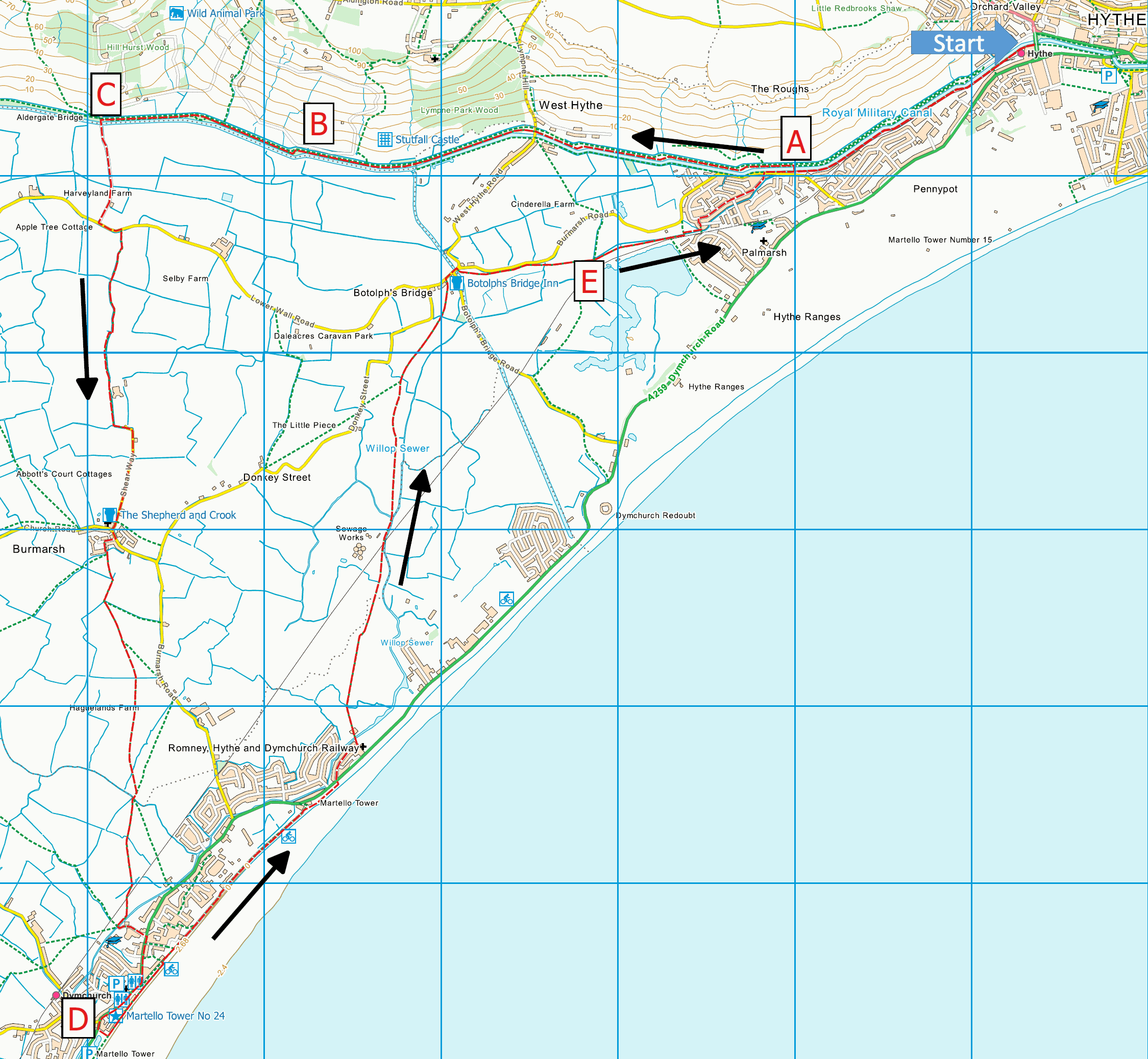
Hythe, Royal Military Canal, Romney Marsh and
Dymchurch
Distance: 12.8 miles (6
Hours) circular or 7 miles (3.5 Hours) and a bus or
train ride back from Dymchurch
OS Map: Explorer 138 (Start
at grid reference TR154347)
Click on map for larger version and click again to
magnify
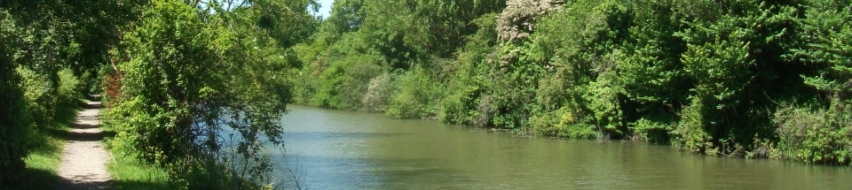
Take the footpath between the
station and the south bank of the Canal. After 1 mile
cross at a footbridge over the Canal try out the model
of the “Listening Ears”. (Point A) Continue along the
north bank and after 1 mile cross West Hythe Road and
choose either the high level footpath or the wider
bridle path. Look up to the right and see the ruined
Roman Stutfall Castle, Point B, and mediaeval Lympne
Castle high on the hill. Further along, you may see
exotic animals behind the fences of the Port Lympne Wild
Animal Park. At Aldergate Bridge at the end of the zoo
fencing (the 3.5-mile Point C), turn left down the lane
to Lower Wall Road. Turn left for 100 yards, then cross
to a bridleway beside a canal across fields; follow
signs to the right of Abbott’s Court farm then turn
sharp left at the end of a paddock. At the road, turn
right along Shear Way into Burmarsh. Shepherd and Crook
pub.
Turn left at the pub, then
cross the road and turn right into The Green. A path 2nd
left leads into fields; the next part is tricky – you
may have to go round field edges! Stay right of a
pillbox then left over a bridge, right on the southbound
path then cross another stile and bridge; follow the
line of electricity poles to a bridge, bear slightly
right to a marker, then slightly left across to a series
of 2 bridges. Bear right through a hedge across to a
sheepfold and the RH&DR line to reach Dymchurch Primary
School. Go left into New Hall Close, on to the main A259
road and turn right for Dymchurch town Point D. Plenty
of pubs, cafes, toilets shops, and a seaside funfair.
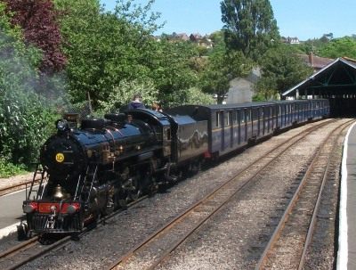
You have walked about 7 miles – if this is enough, there
are plenty of buses or, for a rare treat, catch the
famous miniature steam-driven RH&DR train to take you
back to Hythe.
If you have energy left, walk east
along the sea wall to a Martello Tower. Leave the wall,
cross back over the A259 and turn right. Take the left
turn marked Tower Estate and walk to the end. Turn left
across a bridge and through a farm gate. Keep right of
the farm bungalow and straight across a paddock to a
bridge on the right over a stream. The path leads
diagonally ahead over fields to a 4-bar gate and back
across the railway line; keep right of the sewage works.
Follow the stiles/gates through several fields, keeping
a canal on the right, then over a stile to Lower Wall
Road just left of Botolph’s Bridge Inn. Turn right and
cross over the crossroads. After a few yards, climb a
stile on the right into pasture; spot the tin wagon;
then follow the hedge until it turns to the left. You
now bear right, crossing a canal down towards Nicholl’s
Quarry Lake, watch the dinghies sailing on the lake,
(Point E), and follow the railway line into a housing
estate, the village of Palmarsh. Thread up left through
the estate and on to the Burmarsh Road. Cross over and
turn right; there are many gaps in the hedge to take you
back onto the path beside the Canal leading to the
station.
 This walk was originally
published on a calendar produced by White Cliffs Group.
Thanks to Rhona Hodges for originally devising this
route, Diana Backwell for checking the directions and
Andrew Boultbee for the idea. All photographs by
Robert Peel. This walk was originally
published on a calendar produced by White Cliffs Group.
Thanks to Rhona Hodges for originally devising this
route, Diana Backwell for checking the directions and
Andrew Boultbee for the idea. All photographs by
Robert Peel.
|
Points of Interest
A “Listening Ears” model at Palmarsh Bridge
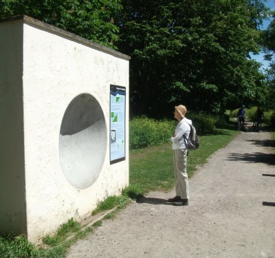
“Listening ears” or sound mirrors are concrete
structures built in the 1920s and 1930s to focus the
sound of incoming aircraft onto microphones placed at
appropriate points as an early warning system. The
invention of radar made them obsolete before they had
been fully deployed.
At the northern end of Palmarsh bridge is a model sound
mirror and information board. It is possible for two
people to test the operating principle of sound mirrors
if one of them stands on a platform on the south bank of
the canal and speaks quietly while the other stands by
the mirror to hear what is being said.
Learn more about sound mirrors in Kent from our
Guide to the Kent Coast
Path.
B Stutfall Castle
The original Roman Port, Portus Lemanis, was sited here
at the then mouth of the Rother, at that time called the
Limen (meaning elm) and hence the names Lemanis and
Lympne. Around 270 AD the Romans built a fort here, one
of the Saxon Shore forts built to defend Britain against
raids by Saxons and Franks. The other Saxon Shore forts
in Kent were at Dover, Richborough and Reculver. The
Saxon Shore Way, a long distance walk from Gravesend to
Hastings, pioneered by the Ramblers with the support of
Kent County Council and which opened as far as Rye in
1980, is named after these forts.
C Zoo Park Western Boundary
The zoo at Port Lympe (pronounced “Lim”) was opened in
1973 as an extension to John Aspinall’s Howletts Wild
Animal Park at Bekesbourne near Canterbury.
D Dymchurch – Martello Tower
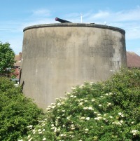
Read about Martello towers, built as defences against
invasion by Napoleon, in our
Guide to the Kent Coast
Path.
E Nicholls Quarry Lake
The lake, created by gravel extraction and subsequent
flooding, is used for fishing and sailing. The site is
undergoing residential development (“Martello Lakes”)
with the lake retained as a major feature.
Our book of
Ten Favourite Walks in the Kent Countryside has
routes for ten more walks like this one.
Ramblers' volunteers in Kent work tirelessly to
ensure that our paths are as well protected and
maintained as possible. Of course we also organise
led walks but most of our members are independent
walkers who simply want to support our footpath work.
Please
join us and become a supporter too. You need
us and we really need you.
|