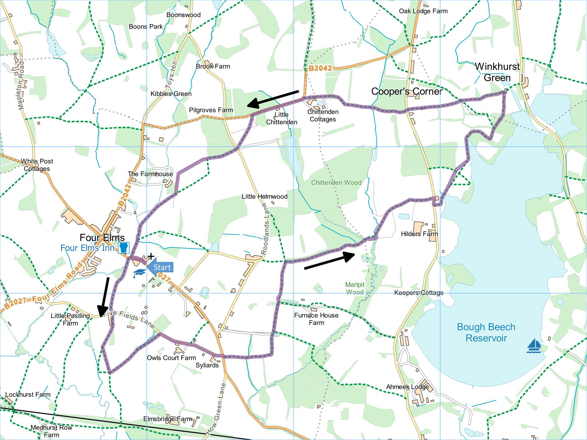
Four Elms and Bough Beech Reservoir
Distance: 5.2 Miles (2h 30m)
OS Map: Explorer 147 (Start at grid
reference TQ470481)
Click map to enlarge and click
again to enlarge further
Park in lay-by opposite church.
Walk past school and house on left and take footpath
on left between fence and stream then along right hand
side of field to Five Fields Lane.
Take tarred path opposite. After gate and stile
(lift top bar to pass), bear right across field around
one stile and on to climb next stile (several metres to
left of field gate). Follow left hand edge of field and
at corner climb another stile.
Turn sharp left along path between fence and hedge.
Climb stile and cross bottom of field (field on left,
fence on right) then at first bend go over stile and
footbridge on right. Turn left uphill to Five
Fields Lane.
Turn right past Owls Court and Syliards Farm to
T-junction with How Green Lane. Take the path
opposite (stile/gap by gate marked Oak Farm) down left
hand side of field to stream at bottom. Take path
immediately to left of field gate climbing between
fences to gate. Through gate bear right to line of
trees then bear left along path through trees to gate into lane. Go straight forward along lane.
When lane bends right, go through gap by a gate on
left and then through gate in corner of hedge.
Cross left hand edge of field and go through gate.
Cross left hand edge of another field. At corner
turn right downhill along broad track along edge of
field with strip of woodland on left. Look across
field to your right to note Marlpit Wood – see Points of
Interest.
Keep going straight forward for as long as you can
until you are in corner of field. Go through gate
on left, then turn sharp right and cross footbridge into
next field. Cross field diagonally; gate is to
left of far corner. Through gate turn right along
field edge. On reaching pedestrian gate in hedge
on right, go through and turn left with hedge now on
left, until you reach lane.
Turn right and then take footpath on left just past
pair of houses (Lakefield Farmhouse). Follow path
down side of one house and then along backs of both.
When path emerges into field, follow line of electricity
wires and poles to corner of wood, then bear half right
downhill to kissing gate. Turn left with view of
reservoir on right. Follow path round wood.
On emerging from wood, go straight across field, through
young oak woodland and down right hand edge of next
field to corner by oast house that formerly housed Kent
Wildlife Trust visitor centre (see Points of Interest).
Don’t go through gate but turn left uphill along right
hand edge of field and take left gate at junction of
paths. Continue along path then track to road at
Piggotts Cottage.
Take the path opposite between hedge and fence.
Follow this path to bottom of valley, then up other
side. When you reach two gates, path is a little
hard to find. Don’t go through either gate but
take path on right between hedge and fence until it
emerges into field. Bear left towards far left
corner of field but climb stile a few metres before you
get there. Follow the path down to road (B2042).
Join road at corner. Take care! Turn left
and follow road round corner, first gently downhill,
then gently uphill to squeeze stile on left after 350
metres. Cross short section of woodland by pond to
gate and cross next field diagonally, going through gap
in hedge just to left of corner (between two large
oaks). Continue in same direction (aiming for
electricity poles) to gate, cross Roodlands Lane and
take path opposite.
Go down edge of field with wood on right. When you
get to end of wood, the path is supposed to turn sharp
left into middle of field and then turn 45 degrees right
and cross to stile at left hand end of hedge.
However, there is no obvious path on the ground and you
may prefer to follow clear path round edge of field
until you reach same stile at bottom – this is route
shown on map. Over stile, cross two fields
diagonally and cross right hand edges of two more fields
to road. Turn left back to starting point.
.
|
Points of Interest
St Paul's Church
Built in the 1880s and designed by Edwin Thomas Hall
(who designed Liberty’s in Regent Street), St Paul’s may
be the oldest concrete church in England. The fine
interior contains work by William Lethaby and others in
the Arts and Crafts movement.
Furnace House
This Grade II listed timber framed house was built in
the late 16th or early 17th century and the roof later
remodelled to create a greater overhang. The name
suggests that the house was built by the owner or
manager of a furnace during the heyday of the Wealden
iron industry and is indeed very close to two furnaces
believed to have been operating around 1589, probably by
Thomas Browne whose family was very prominent in the
industry.
Marlpit Wood
There are many references to marl pits on maps of Kent.
Marl is a rock layer consisting of a mixture of clay and
chalk. It has been excavated since Roman times as a
fertiliser – the name is derived from a Latin word for
fertiliser. A marl layer is often found in association
with ironstone – hence Furnace House Farm not far from
the wood.
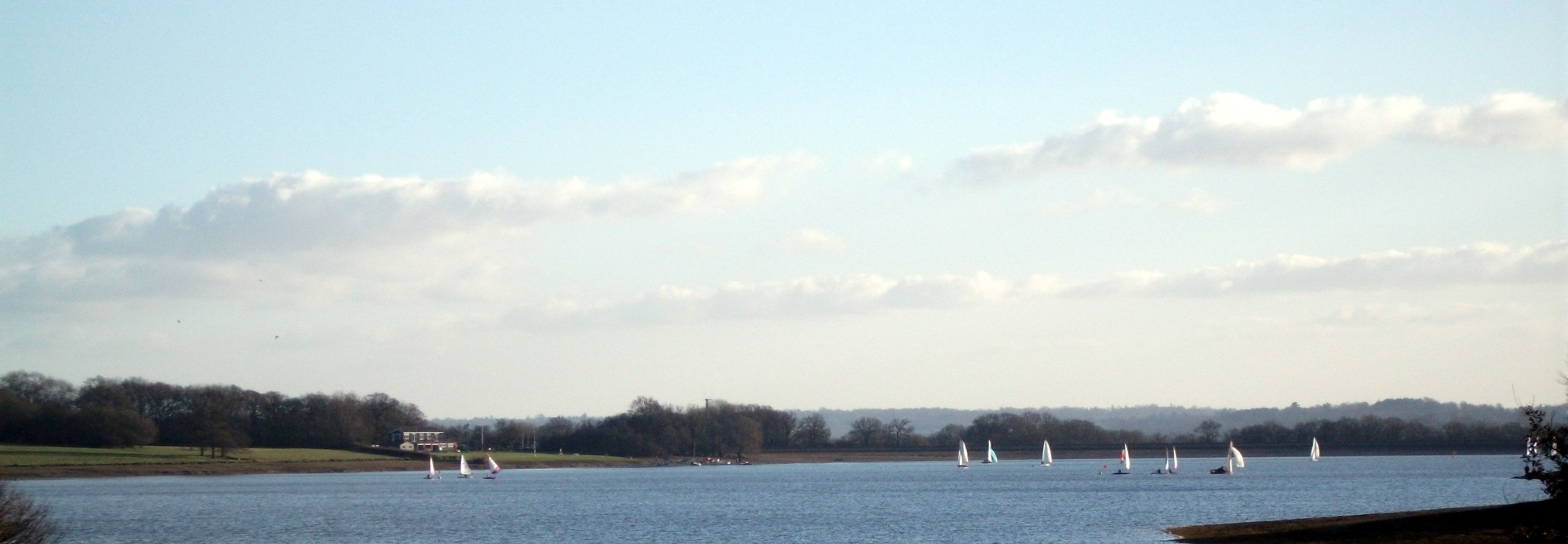
Bough Beech
For many years the area you pass through alongside
the reservoir was managed as a nature reserve by Kent
Wildlife Trust with a visitor centre at the oast house.
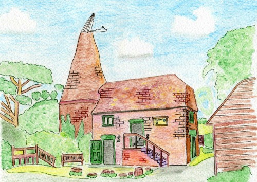
Sadly the visitor centre was closed at the end of
2017 and at the time of writing the Trust appears to
have withdrawn completely from the site which is owned by Sutton
and East Surrey Water. There is parking on the lane
where it divides the reservoir and it is rare not to see
birdwatchers here with their binoculars and zoom lenses.
The reservoir itself is filled in winter by pumping
water from the River Eden for purification and use by
SES Water during the drier summer months.
White "Stiles"
You will see a series of white structures that look a
little like stiles but no path goes over them. These
follow the route of a pipeline and are presumably to
enable the route to be followed from the air.
Public Transport
Unfortunately there are no bus or rail services
convenient for this walk.
In addition to the walking routes on our web site we
have published three popular walking guides:

Guide to Tunbridge
Wells Circular Walk and other walks in the area

Guide to the
Kent Coast Path: Part 1, Camber to Ramsgate

Guide to Three
River Valley Walks in West Kent: Darent Valley Path,
Eden Valley Walk and Medway Valley Walk
Please report any problems with this walk to
info@kentramblers.org.uk.
Ramblers' volunteers in Kent work tirelessly to
ensure that our paths are as well protected and
maintained as possible. Of course we also organise
led walks but most of our members are independent
walkers who simply want to support our footpath work.
Please
join us and become a supporter too. You need
us and we really need you.
Map contains Ordnance Survey data © Crown copyright
and database rights 2021. Some paths on map are based
on data provided by Kent County Council but do not
constitute legal evidence of the line of a right of way |